Recently, the Committee decided to open up to new categories such as cultural landscapes and routes, industrial heritage (for example, this year, Ivrea, the industrial city of the 20th century, in Italy), deserts, marine sites coastal and small island sites, so that the list is more diverse and more representative of World Heritage. The sites proposed for inscription must meet at least one of the ten selection criteria, such as, for example, representing a masterpiece of human creative genius, testifying to an exchange of influences during History, to bear exceptional testimony to a cultural tradition or to a living or extinct civilization, or else to represent natural phenomena of exceptional beauty and aesthetic importance or, of course, to be eminently representative examples of ecological and biological processes … Italy is the country with the largest number (54), followed by China (53), Spain (47), France (44), Germany (44), and finally, Mexico (35).
China: Fanjingshan, a very rare ecosystemSouth Korea: the Sansa, mountain Buddhist monasteriesFrance: the Chaine des Puys Tectonic High Place – Limagne FaultAustralia: Budj Bim Cultural Landscape
Icelanders don’t have a nickname, they use a handy system by which they match the son’s name with the father’s in each generation. At the same time, families do not identify themselves by a nickname or family branch, something very different from what we are used to.
There is no private health or education, public services are so good that there are no complaints. More books are bought per inhabitant than in any other country. They invented the Icelandic sagas, the most similar to a novel.
Geyser is one of the few Icelandic words exported to the world through English, which incorporates the ending to refer to the well-known geological phenomenon that occurs on the island and which is almost universally used.
The Icelandic language is only used in Iceland and is very similar to some Scandinavian languages, especially Old Norwegian.
It is not a very populated country, it has 360 000 inhabitants, half of them concentrated in the capital – Reykjavik – being one of the countries with the most concentrated population in the world and the safest.
It is a pioneer country in terms of implementing democracy. Presumably it has the oldest democratic system in the world, founded some 1000 years ago. In 1996 gay marriage was legalized.
In Iceland, water (from rain and nature reserves) is so abundant and uncontaminated that what is consumed reaches homes without any type of treatment. The large number of thermal sources provides an efficient and inexpensive heating system for homes. In Summer there are 24 hours of light.
Winter is not as cold as you might think, due to the relation of its latitude and the moderation of the ocean. The daytime temperature is around 0°C. Volcanic-type underground channels provide free hot water. There are 33 volcanoes and it is the country with the most and largest documented volcanic eruptions.
Iceland is the only NATO country that does not have armed forces, which were abolished in the 13th century. Only a tiny fraction of the country’s 679 police – a crisis unit called The Vikings – use guns. The annual murder rate is less than five and the total amount of the imprisoned population is 118. Iceland has the highest density of mobile phones per capita in the world. There are more mobile phones than inhabitants, and ¾ of the population has an Internet connection.
Iceland from spaceBlue Lagoon fenceIceland’s blue skyBlue calcite, close to a geothermal phenomenon.Cookie IslandExploring the Valleys Beyond and the Akureyri Fjords
GULLFOSS
Gullfoss, the Golden Cascade, is a cataract located on the Hvítá River in southeastern Iceland. It is one of the most popular attractions in the country. It is located on the wide bed of the Hvítá river, which runs to the south and a kilometer from the waterfall turns abruptly to the east, falling in three curved steps. At that moment, the water falls in jumps: 11 and 21 m, in a crack 32 m deep, some 20 m wide and 2,5 km long. The average flow in this cataract is 140 m³/s in Summer and 80 m³/s in Winter. The maximum measured water flow is 2000 m³/s. When the visitor approaches the waterfall, the crevice hides the view, giving the feeling that the mighty river simply disappears underground.
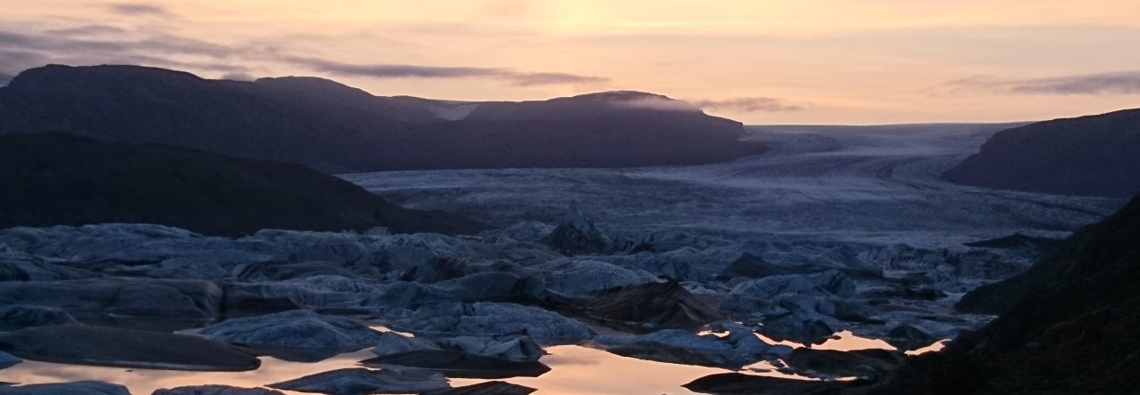
GullfossVolcanoJokulsarlon LagoonLandmannalaugar or People’s PoolsMountains and Lake Frostastadavatn in South HighlandNorse Gods in MoonfallStreets of Reykjavik at sunset.Abandoned Church in Icelandic TundraThe Lighthouse. Built in 1939The Orange Mold at Churchyard Tombstones
SKOGAFSS
Skogaföss is one of Iceland’s largest, most beautiful and impressive waterfalls. According to legend, the first Viking inhabitant buried his treasure in a cave behind this waterfall.
Eruption of FimmvorduhalsColored clouds over IcelandHunafloi BayNorthern Iceland. Lights above the gray clouds of the Eyjafjallajokull Volcano
BLUE LAGOON
Blue Lagoon is a natural geothermal resort, surrounded by lava fields and sandy beaches. Relaxing in this lagoon, in a vaporous environment, is captivating, providing a pleasant experience. The temperature is 37-39 °C.
The Blue Lagoon is famous for its unique active ingredients and their effects on the mind and body. Salts, silica and sulfur provide well-being. Algae give blue, green and nutrients. White silica, cleansing slime, and massage are highly recommended.
GLAUMBAER
Glaumbær is a town and former parish of the Icelandic community of Skagafjörður.
THE END
An amazing journey throughout the beauty, uniqueness and astonishingly Icelandic landscapes…
Sitting astride the Mid-Atlantic Ridge…The only place where the Mid-Atlantic Ridge rises above sea level.The Mid-Atlantic Ridge (Divergent tectonic plate boundary) attracts tourists.
Volcanic Activity
Volcanic eruptions are far more frequent on convergent tectonic plate boundaries (Cascade Mountain Range & the Andes) than on divergent tectonic place boundaries (Iceland); however, eruptions do occur along divergent boundaries. Recently and eruption broke through the icecap in Iceland.
Iceland’s Eruptions
Ash and roughly thirty-story-tall lava fountains shoot from a half-mile-long (0.8-kilometer-long) rupture in the icy cap of southern Iceland’s Eyjafjallajokull (pronounced AY-uh-full-ay-ho-kul) volcano early Sunday.
The geology of Iceland, though, is anything but normal. The volcanic island lies just south of the Arctic Circle atop the Mid-Atlantic Ridge, where two tectonic plates are forever pulling apart. Magma from deep inside Earth rushes upward, filling the gaps and fueling Iceland’s volcanic eruptions, which occur about once every five years.
• From a different angle, Eyjafjallajökull’s “lavafall” appears unobstructed by billowing steam, revealing the glowing yellow ribbon cascading down the rocky gorge on March 26, 2010.• Lava spraying high into the air draws crowds of tourists to Iceland’s Eyjafjallajökull volcano on March 27, 2010.
• When the eruption started on March 21, hundreds of people were evacuated from their homes, due to fears of flooding, which could have occurred, had the volcano’s heat melted too much surrounding glacial ice.Cooling lava flowsTourists check out the cooling lava
Comparison
These eruptions tend to be much less violent and destructive than those of strato-volcanoes that form near convergent boundaries.
1980 when Mt. St. Helen erupted in the Cascade Mountains, nearly half of the mountain was blown away.
In Iceland the magma comes up to fill in a gap created by the separating of the two tectonic plates.
• Not far from Eyjafjallajokull glacier, the much larger Mýrdalsjökull glacier (check the map on the next slide) hides the fiery, gently sloping Katla volcano that lies under the ice.
Eruptions on Iceland
An incandescent basaltic lava flow winds its way downslope from a vent at Krafla volcano in Iceland in 1984. The flow originated from an 8.5-km-long fissure that was initially active along its entire length. The fissure was produced by rifting along the mostly submarine Mid-Atlantic Ridge where it rises above sea level and cuts across the island of Iceland, forming an accessible natural laboratory for studies of episodic eruptions at this oceanic spreading ridge.
Krafla Volcano – Iceland
An incandescent basaltic lava flow winds its way downslope from a vent at Krafla volcano in Iceland in 1984. The flow originated from an 8.5-km-long fissure that was initially active along its entire length. The fissure was produced by rifting along the mostly submarine Mid-Atlantic Ridge where it rises above sea level and cuts across the island of Iceland, forming an accessible natural laboratory for studies of episodic eruptions at this oceanic spreading ridge.
Iceland Info.
Area: 103,000 sq km
Coastline: 4,970 km
Terrain: mostly plateau interspersed with mountain peaks, icefields; coast deeply indented by bays and fiords •Land use: –arable land: 0.07% –permanent crops: 0% –other: 99.93% (2005)
Infant mortality rate: 3.23 deaths/1,000 live births
Life expectancy at birth: 80.67 years
Adult literacy: 99%
Economy
GDP – per capita (PPP): $39,800 (2009 est.) –$42,800 (2008 est.) –$42,600 (2007 est.)
GDP – real growth rate: -6.3% (2009 est.) –1.3% (2008 est.) –5.5% (2007 est.)
GDP – composition by sector: –agriculture: 5.2% –industry: 24% –services: 70.8% (2009 est.)
Reykjavik –Capital City
ReykjavikRoundup of Icelandic horsesThe Gullfoss (Golden Falls) Waterfall in southern Iceland.An eruption of the geyser Strokkur.A river with volcanic black sand banks meanders to the sea through farm fields near the southern coast of Iceland.Looking across the plate boundary from the European Plate to the N. American.
I am not the author of the words nor the photographs. I give thanks to the person who compiled the info about one of the most beautiful places I’ve had the honour to visit, already!